News that matters in AmericaReporting on public life and the stories shaping the United States.
Flood Watches are active across parts of Texas today, including the Houston area, Southeast Texas, South Texas and Deep South Texas. Residents and travelers should monitor National Weather Service alerts, avoid flooded roads and be ready to act if warnings are issued.
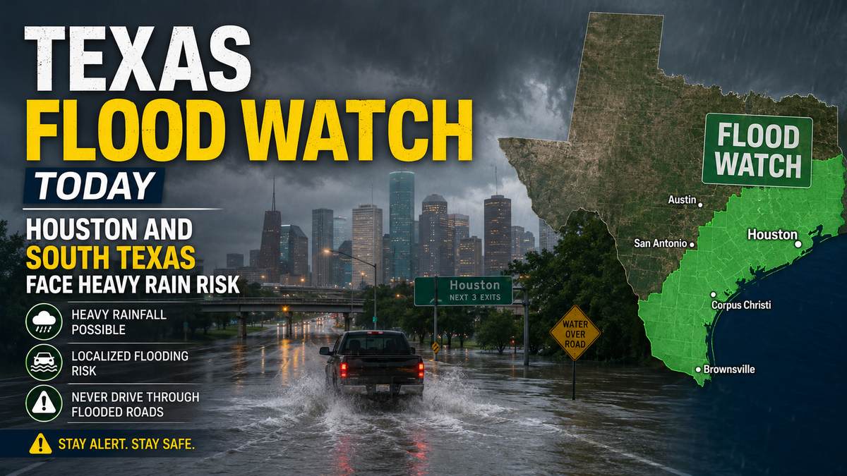
Flood Watches are in effect across large parts of Texas today, including Houston, Southeast Texas, South Texas, Deep South Texas and parts of South Central and East Texas. Residents and travelers should keep checking National Weather Service alerts, avoid flooded roads and be ready to move to higher ground if a Flash Flood Warning is issued.
The broadest watch affecting the Houston area covers Southeast Texas and remains in effect through Thursday morning, according to the National Weather Service Houston/Galveston office. The watch includes Harris, Fort Bend, Brazoria, Galveston, Montgomery, Liberty, Chambers and other counties, with extensive street flooding and flooding of creeks and rivers possible.
South Texas and the Coastal Bend are also under Flood Watches through Thursday morning. The National Weather Service office in Corpus Christi said intense rainfall could produce isolated pockets of 6 to 8 inches or more, with rain rates high enough to cause rapid flooding in vulnerable areas.
In Deep South Texas, the National Weather Service Brownsville/Rio Grande Valley office said a Flood Watch covers the entire region into Thursday morning. Estimated rainfall totals are 5 to 10 inches, with isolated amounts of 12 inches or more where heavier showers or thunderstorms persist.
A Flood Watch also covers parts of South Central Texas through Tuesday evening, including counties east of Interstate 35 and south of U.S. 90, the Austin/San Antonio forecast office said. Deep East Texas counties, including Angelina, Nacogdoches, Sabine, San Augustine and Shelby, were also included in a watch through Tuesday evening in the latest National Weather Service alert product.
Several official forecasts point to the same concern: repeated heavy rain over areas that may already be saturated.
The Weather Prediction Center said the highest early Tuesday probabilities for flash flooding were across Deep South Texas, with the rainfall threat shifting north and east along the Texas coast and into Louisiana. The National Hurricane Center is also monitoring a disturbance near the Texas-Mexico border that could move back over the northwestern Gulf.
The hurricane center said there were no tropical cyclones in the Atlantic at the latest check, but it gave the disturbance a medium chance of becoming a short-lived tropical storm later Tuesday or Wednesday. Forecasters said that, regardless of tropical development, southern and eastern Texas should prepare for periods of intense rainfall that could produce flash, urban and river flooding.
A Flood Watch does not mean flooding is happening everywhere in the watch area. It means conditions are favorable for flooding, and warnings may be issued quickly if heavy rain develops or if water begins rising.
A Flash Flood Warning is more urgent. If one is issued for your area, move away from low spots, creeks, bayous, underpasses and flood-prone roads. People in flood-prone homes, campgrounds or low-water crossing areas should be ready to act before water rises.
Do not drive through water covering a road, even if it looks shallow. The National Weather Service warns that flooded pavement can hide washed-out roadbeds, fast-moving water or debris.
Travelers should check road conditions before leaving, especially on routes through Houston, the Coastal Bend, the Rio Grande Valley, South Central Texas and low-water crossing areas. The Texas Division of Emergency Management said state resources were activated for the flood threat and urged Texans to monitor forecasts, follow local officials and avoid flooded roadways.
Keep phone alerts on overnight and have more than one way to receive warnings. Heavy rain can repeatedly train over the same area, and flash flooding may develop faster than normal traffic or travel plans can adjust.
For the latest alert status, use the National Weather Service alerts page or the local forecast office covering your area. Houston-area residents should check the Houston/Galveston office. Coastal Bend residents should check Corpus Christi. Rio Grande Valley residents should check Brownsville/Rio Grande Valley. South Central Texas residents should check Austin/San Antonio.
For broader rainfall risk, check the Weather Prediction Center’s excessive rainfall outlook. For the Gulf disturbance, check the National Hurricane Center’s tropical weather outlook.
Road and closure information can change faster than regional forecasts. Drivers should use the state’s DriveTexas road-condition service and local emergency management updates before traveling.
This article should be refreshed as new Flood Watches, Flash Flood Warnings, river warnings or tropical weather updates are issued.