News that matters in AmericaReporting on public life and the stories shaping the United States.
Use official Spokane County evacuation resources to check current Upriver Fire evacuation levels by address. Level 3 areas remain the highest-risk zones and residents should follow Alert Spokane and incident-command updates.
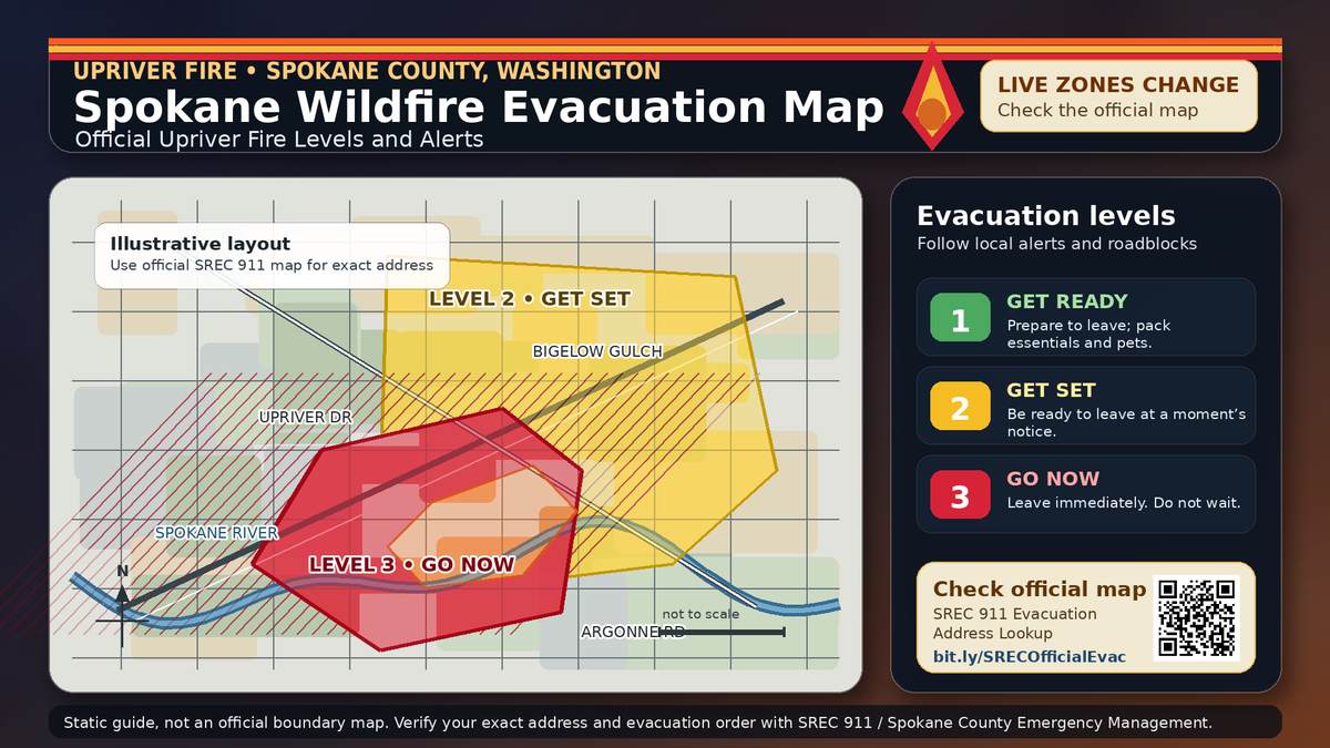
The official Spokane wildfire evacuation map for the Upriver Fire is the Spokane Regional Emergency Communications Evacuation Address Lookup Map. Evacuation levels were revised Wednesday night, with some areas reduced, but Level 3 areas remained closest to the fire perimeter; anyone in a Level 3 area should leave immediately.
Use the address lookup and Alert Spokane notifications before making decisions for a specific home. Evacuation zones can change quickly, and older screenshots or reposted maps may be out of date.
Spokane Regional Emergency Communications, the county’s 911 partner, hosts the evacuation address lookup for Spokane County. Spokane County Emergency Management also directs residents to the fire evacuation map and says it was created by its 911 partners.
The safest way to use the map is to search the exact address you are checking. That matters because evacuation levels may not follow a simple street-by-street pattern, and nearby homes can fall under different levels as incident command adjusts the perimeter.
Residents should also register for Alert Spokane if they have not already done so. Spokane County Emergency Management says registration is the way to receive public alert and warning notifications about fires, law enforcement activity or other emergencies near a registered address.
The latest public evacuation update found during the check said updated levels took effect Wednesday night. Fire officials said some evacuation areas were reduced, while Level 3 evacuations remained in the areas closest to the fire perimeter.
Level 3 remains the highest evacuation level and access is not permitted until authorities say conditions are safe. People in Level 2 areas should be ready to leave at a moment’s notice, especially if they need extra time to move children, older adults, pets or livestock.
A Wednesday afternoon update from the incident management team, reported by KHQ, put the Upriver Fire at 222 acres and 10% contained, with about 300 personnel assigned. The fire has been burning in the Beacon Hill and Upriver Drive area east of Spokane, where roadblocks and fire operations may continue to affect access.
Level 1: Get ready. Conditions could get worse, so prepare to leave and keep essential items close.
Level 2: Get set. Dangerous conditions may threaten the area, and residents should be ready to leave at any time. People who need extra time, or who have pets or livestock, are encouraged to leave early.
Level 3: Go now. There is an immediate threat to safety. Leave immediately, bring pets if possible and do not return until officials clear the area.
The American Red Cross opened support for Upriver Fire evacuees at Spokane Valley United Methodist Church, 115 N. Raymond Road in Spokane Valley. The Red Cross says emergency shelters are open to anyone affected by a disaster and can provide a place to get a meal, charge a phone and connect with resources.
No identification is required at Red Cross shelters, and people do not have to stay overnight to receive help. If there is time and it is safe, evacuees should bring medication, important documents, hygiene supplies, clothing, blankets and needed items for children, pets or infants.
Do not return to a Level 3 area because a map image appears old or because smoke looks lighter. Use the official address lookup, follow Alert Spokane messages and obey roadblocks.
Residents should expect conditions to change as crews improve containment lines and reassess hazards. Check the official map again before leaving a safe location, especially after any new notice from Spokane Regional Emergency Communications or incident command.