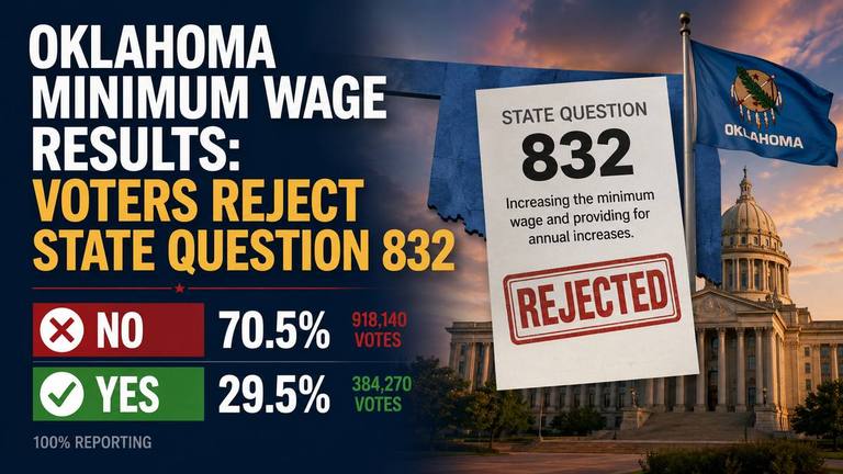
News that matters globallyReporting on public life and major developments across the U.S., the UK, and beyond.
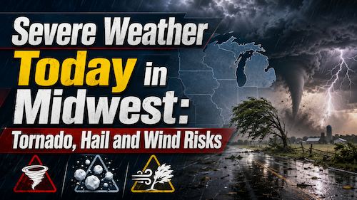
NWS outlooks place parts of the Central U.S. under severe thunderstorm and heavy rainfall concerns today. Large hail, damaging winds, tornadoes and flash flooding are possible from the central Plains toward the Midwest and Ohio Valley.
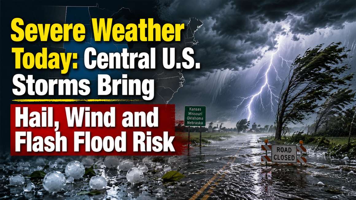
Severe weather today is focused on the central United States, where National Weather Service outlooks call for thunderstorms and heavy rainfall from the central High Plains into the Midwest and Ohio Valley. People in the risk area should keep alerts on, watch for fast-changing local warnings and avoid any flooded roads through tonight.
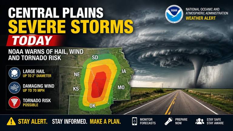
The Storm Prediction Center placed a Slight Risk of severe thunderstorms from parts of the central Plains into the mid Mississippi and lower Ohio valleys. The risk runs mainly from this afternoon into tonight.
The main storm hazards are large to very large hail, damaging wind gusts and tornadoes. The SPC said some wind gusts could top 75 mph, and a stronger tornado risk could develop across parts of Missouri, Illinois and Indiana during the afternoon and evening.
Farther west, isolated supercells could form across eastern Colorado into western Nebraska and western Kansas. Those storms would initially carry a risk of large hail, including isolated hail larger than 2 inches, before any clusters raise the wind threat this evening.
The Weather Prediction Center has a Moderate Risk of excessive rainfall in effect for parts of the central Plains, middle Mississippi Valley and Ohio Valley. That includes a corridor where storms and saturated ground could produce scattered flash flooding.
The WPC said the flash flood threat today extends from Kansas to Indiana, with locally significant flooding possible where heavy storms repeat over the same areas. Parts of Missouri, Illinois and Indiana are of particular concern because recent rain has left soils wet and some rivers elevated.
Kansas and southwest Missouri are also being watched for additional heavy rain. The WPC forecast discussion described potential rainfall amounts of 3 to 4 inches in parts of that zone, with localized higher totals possible.
Convective watches were not in effect nationally on the SPC current watches page at its 9:47 a.m. ET update, but that should not be read as an all-clear. The SPC’s next outlook was scheduled for 12:30 p.m. ET, and watches can be issued quickly if storms organize.
Local NWS pages in Kansas and Missouri were already showing flood-related products Sunday morning. The Wichita, Kansas, office listed flash flood warnings, flood warnings, flood advisories and flood watches on its local hazards map. NWS offices serving Topeka and Kansas City also listed flood watches and flood warnings in their coverage areas.
A watch means conditions are favorable and people should be ready. A warning means the hazard is happening, imminent or likely, and people in the warned area should take action.
Keep at least two ways to receive warnings, especially if you will be driving, at an outdoor event or away from shelter. Wireless Emergency Alerts, NOAA Weather Radio, local NWS office pages and trusted local broadcasters can help fill gaps if one source is delayed.
NOAA’s Storm Prediction Center placed parts of the Central Plains under an Enhanced Risk for severe storms Saturday, with large hail, damaging wind and a few tornadoes possible. The greatest risk is expected this afternoon and evening, with flash flooding possible into early Sunday.
Parts of the Upper and Mid Mississippi valleys and Midwest face an Enhanced Risk for severe storms Wednesday, with tornadoes, large hail and damaging winds possible. Residents should monitor National Weather Service alerts and be ready to shelter if warnings are issued.
For thunderstorm warnings, move inside a sturdy building and stay away from windows. If thunder is close enough to hear, the NWS says lightning is close enough to be dangerous; stay indoors until storms have moved away and thunder is no longer audible.
For tornado warnings, go to a basement or a small interior room on the lowest level. Avoid windows and protect your head from flying debris.
For flooding, do not drive around barricades or through water covering a road. The NWS warns that 12 inches of rushing water can carry away most cars and 2 feet can carry away SUVs and trucks.
The severe weather area can shift as morning storms, outflow boundaries and afternoon heating change the setup. Readers in Kansas, Missouri, Oklahoma, Arkansas, Illinois, Indiana, Kentucky, Nebraska and eastern Colorado should check their local NWS office before travel and again before evening plans.
This article should be updated after new SPC outlooks, new watches, local warnings or major WPC rainfall updates.
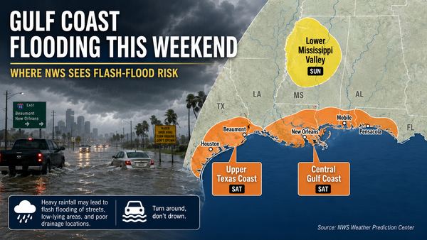
Parts of the Gulf Coast face localized flash-flood risk this weekend as heavy showers and storms move inland from the Gulf. The National Hurricane Center says tropical cyclone formation is not expected during the next seven days.