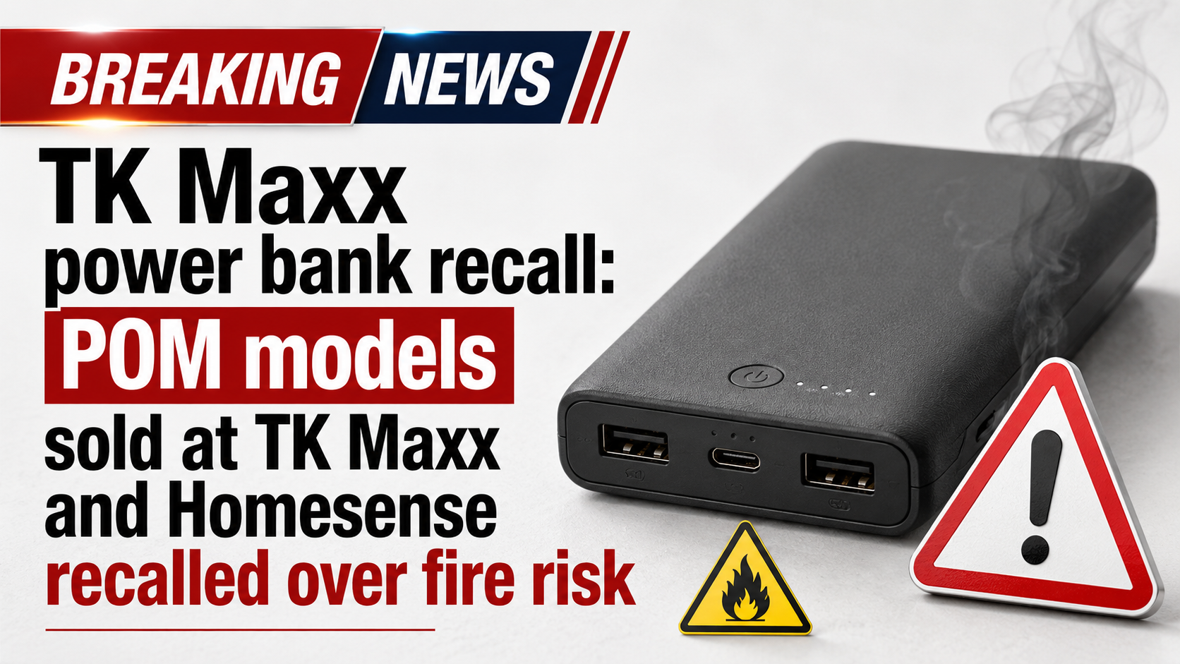
News that matters in AmericaReporting on public life, technology, money, and policy in the United States.
Parts of the Gulf Coast face localized flash-flood risk this weekend as heavy showers and storms move inland from the Gulf. The National Hurricane Center says tropical cyclone formation is not expected during the next seven days.
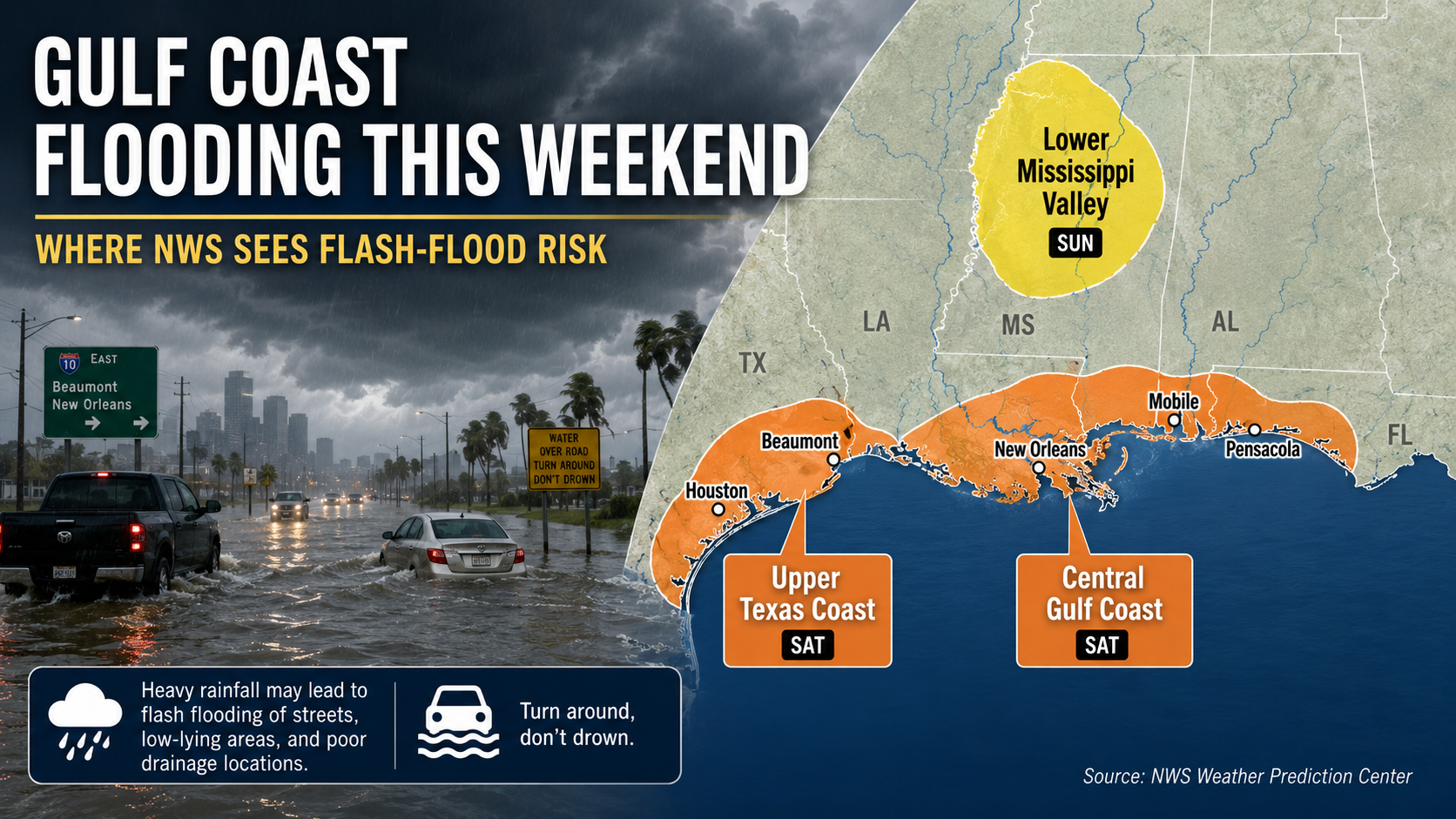
Parts of the Gulf Coast face a localized flash-flood risk this weekend as deep Gulf moisture fuels slow-moving and repeating thunderstorms. The National Weather Service is highlighting the Upper Texas Coast and the central Gulf Coast on Saturday, while the National Hurricane Center says tropical cyclone formation is not expected in the Atlantic basin during the next seven days.
The Weather Prediction Center’s Saturday excessive-rainfall outlook includes Slight Risk areas for the Upper Texas Coast and central Gulf Coast. A Slight Risk is a level 2 of 4 category, above the lowest-risk Marginal category.
On the Upper Texas Coast, WPC highlighted the I-10 corridor from southwest of Houston toward the Texas-Louisiana border near Beaumont. NWS Houston/Galveston said scattered to widespread showers and storms are expected over the weekend, with the most focused excessive-rainfall concern generally along the I-10 corridor on Saturday. Rainfall rates may peak around 3 to 4 inches per hour, enough to produce a quick 1 to 3 inches or more and localized street flooding.
The central Gulf Coast risk extends roughly from New Orleans east toward Pensacola. WPC said numerous showers and thunderstorms moving north out of the Gulf could repeat along a slow-moving front, with the most persistent rain capable of widely scattered flash flooding by late afternoon.
NWS New Orleans/Baton Rouge said a surface trough drifting north from the central Gulf will bring squalls of heavy rain and storms into Louisiana on Saturday. Storms are expected to be more numerous during the afternoon, though scattered showers and storms could linger Saturday night near the coast.
For southeast Louisiana, coastal Mississippi, south Alabama and the western Florida Panhandle, the issue is timing and placement. A neighborhood that misses repeated downpours may see nuisance rain; a nearby area under training storms can flood quickly.
The Sunday outlook shifts more of the excessive-rainfall concern inland toward the Ozarks, mid-Mississippi Valley and western Tennessee Valley. WPC said the Slight Risk includes areas such as western Tennessee, far northeastern Mississippi and especially northern Alabama, where recent heavy rain has lowered the threshold for flash flooding.
That does not mean the Gulf Coast is fully done with storms. It means the more organized flash-flood threat is expected to migrate north and east as the weekend system evolves.
The National Hurricane Center’s latest Tropical Weather Outlook said tropical cyclone formation is not expected in the North Atlantic, Caribbean Sea or Gulf during the next seven days. NHC also listed no active tropical cyclones in the Atlantic at the latest homepage check.
The flooding threat is being driven by moisture, a front or trough and repeated thunderstorms, not by a named storm or an NHC-tracked tropical depression. That distinction matters, but it does not remove the flood risk: non-tropical systems can still produce dangerous rainfall.
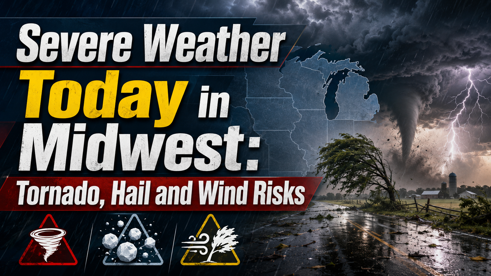
Parts of the Upper and Mid Mississippi valleys and Midwest face an Enhanced Risk for severe storms Wednesday, with tornadoes, large hail and damaging winds possible. Residents should monitor National Weather Service alerts and be ready to shelter if warnings are issued.
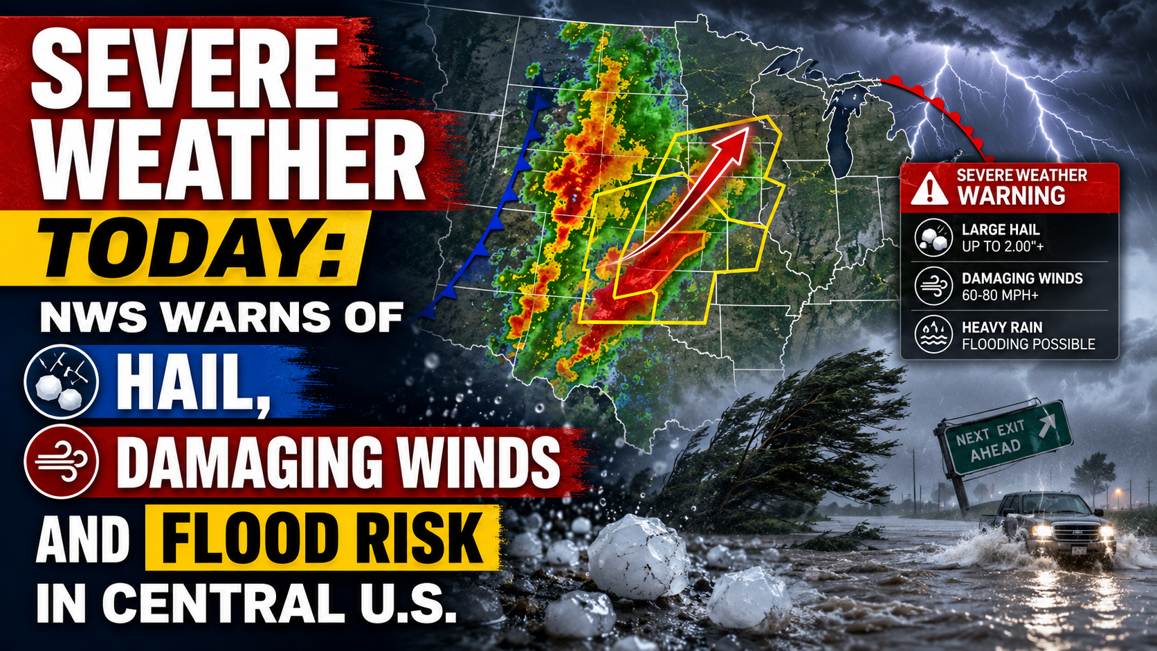
The National Weather Service says parts of the central U.S. face severe thunderstorms today, with large hail, damaging winds, isolated tornado risk and flooding possible. The main risk areas stretch from the central Plains into the Midwest, with a separate heavy-rain threat from Texas into the Mississippi Valley.

Flash-flood-prone spots include urban streets, poor-drainage areas, low-water crossings, small streams and low-lying roads. Do not drive into water covering a road, and do not go around barricades. NWS flood-safety guidance says it is never safe to drive or walk into floodwater.
Beach conditions are also hazardous in some areas. NWS Houston/Galveston warned of a high risk of rip currents at Gulf-facing beaches through at least Sunday morning. NWS Mobile/Pensacola warned of life-threatening rip currents through at least Saturday night for Alabama and northwest Florida Panhandle beaches, with high surf and possible overwash or minor inundation in parts of Dauphin Island and Fort Pickens.
Forecasts, warnings and advisory areas can change quickly. Check local National Weather Service alerts before travel, keep emergency alerts enabled, and be ready to change routes if heavy rain develops.
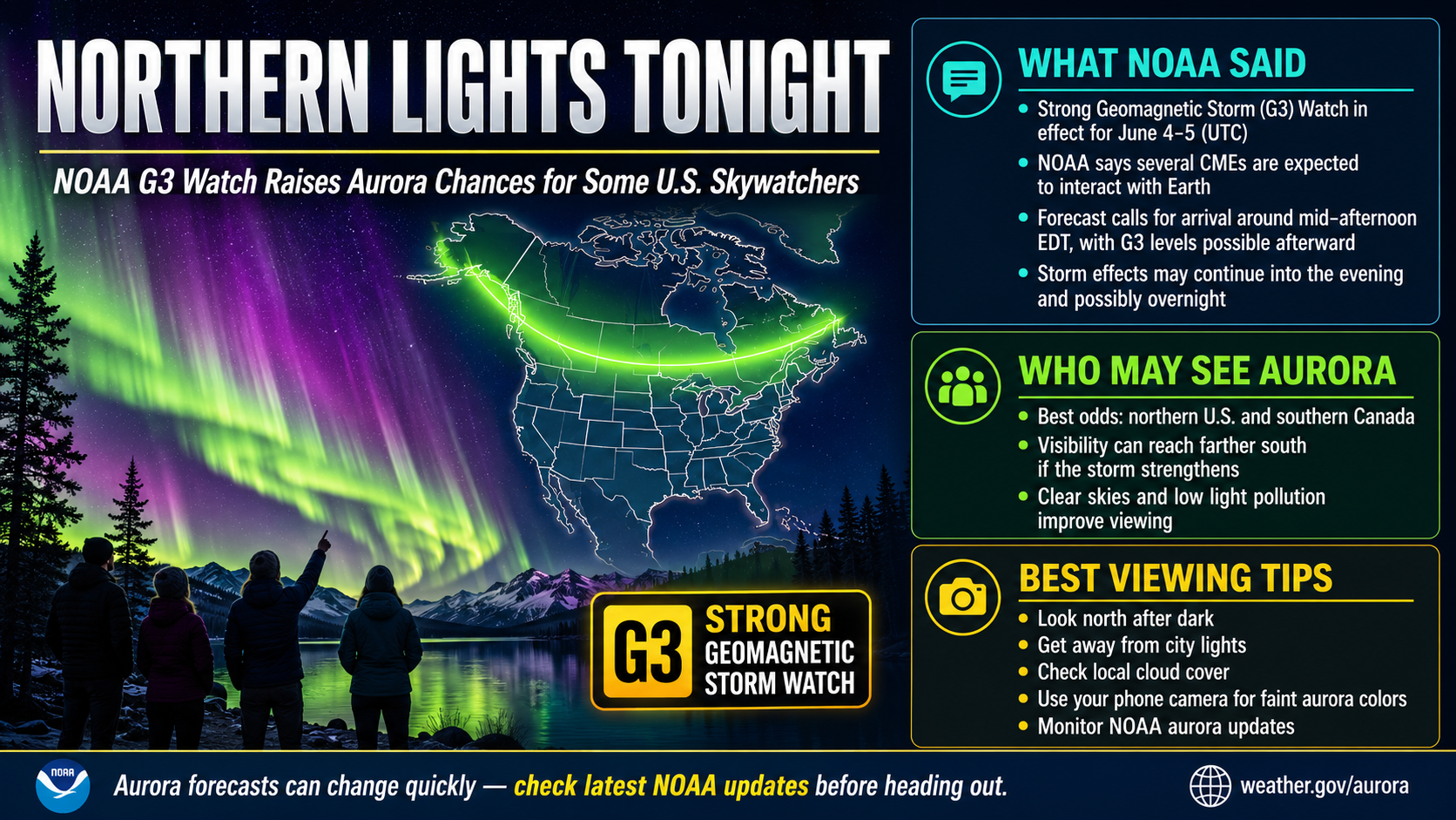
NOAA says a G3 geomagnetic storm watch is in effect for June 4 and June 5 as CMEs are forecast to interact with Earth. Aurora visibility tonight will depend on final storm strength, darkness, cloud cover and the latest SWPC forecast maps.