News that matters in AmericaReporting on public life and the stories shaping the United States.
The National Weather Service says severe storms could affect parts of the Plains and Upper Midwest on Thursday, with risks that include large hail, damaging winds, a couple of tornadoes and localized flooding. Residents should monitor local NWS alerts as storms develop later in the day.
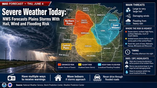
Severe weather today is focused on the Plains and Upper Midwest, where the National Weather Service says storms could produce large hail, damaging winds, a couple of tornadoes and localized flash flooding Thursday. People in the risk areas should check local NWS alerts before afternoon and evening storms develop and be ready to move indoors quickly.
The Storm Prediction Center placed a Slight Risk of severe thunderstorms over portions of the northern Plains. The risk area includes parts of the northern High Plains, northern Nebraska and much of South Dakota, with more isolated severe storms possible farther south across the central Plains.
The Weather Prediction Center described the broader storm corridor as the northern and central Plains into the Upper Midwest. That includes areas near eastern Nebraska, western Iowa, South Dakota, northern Nebraska and southwest Minnesota, with the threat shifting farther east Friday.
SPC said storms that form later Thursday could produce large to very large hail and damaging thunderstorm winds. Supercells are possible where storms develop in upslope flow north of a weak surface low, and a tornado or two could occur where a storm interacts with the front.
Farther southeast, from central Kansas toward central Iowa, multiple rounds of storms may develop during the afternoon and evening. SPC said that area could see strong winds, hail near severe limits and a tornado threat late in the day if storms stay discrete.
Heavy rain is a separate concern. WPC placed a Slight Risk of excessive rainfall over part of the Upper Midwest for Thursday, with the public forecast highlighting eastern Nebraska and western Iowa. A broader Marginal Risk covers much of the Plains into the Upper Midwest.
Rainfall rates of 1 to 2 inches per hour are possible in some storms, WPC said. That can cause problems in urban areas and at low-water crossings, especially where storms repeat over the same locations.
SPC’s current-watch page listed no valid severe thunderstorm or tornado watches in its latest early-morning update. That does not mean the day is clear; it means a watch had not been issued at that check.
A watch means conditions are favorable for severe storms. A warning means dangerous weather is happening or imminent. Readers in the Plains and Upper Midwest should use their local NWS office, NOAA Weather Radio, Wireless Emergency Alerts and trusted local emergency managers for warning-level information.
Charge phones, enable emergency alerts and identify the lowest, most interior room in your home or workplace. If a tornado warning is issued, NWS guidance is to go to a basement, safe room or interior room away from windows.
Parts of the Upper and Mid Mississippi valleys and Midwest face an Enhanced Risk for severe storms Wednesday, with tornadoes, large hail and damaging winds possible. Residents should monitor National Weather Service alerts and be ready to shelter if warnings are issued.
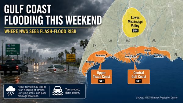
Parts of the Gulf Coast face localized flash-flood risk this weekend as heavy showers and storms move inland from the Gulf. The National Hurricane Center says tropical cyclone formation is not expected during the next seven days.


For severe thunderstorm warnings, move inside a sturdy building and stay away from windows. Bring pets indoors if time allows and secure loose outdoor objects before storms arrive.
For flooding, do not drive around barricades or through water-covered roads. NWS flood-safety guidance says it is never safe to walk or drive into floodwater.
The exact location of the strongest storms and heaviest rainfall may shift during the day. The next meaningful updates are likely to come from SPC outlooks, local NWS watches and warnings, and WPC excessive-rainfall updates as storms develop.
Check official alerts again before driving, outdoor work, evening events or overnight travel in the affected corridor.
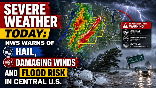
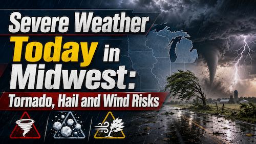
The National Weather Service says parts of the central U.S. face severe thunderstorms today, with large hail, damaging winds, isolated tornado risk and flooding possible. The main risk areas stretch from the central Plains into the Midwest, with a separate heavy-rain threat from Texas into the Mississippi Valley.